

Share /save is the easy way to add us to your favourite list and share with your friends
![]()
|
FLOOD INFORMATION AND PREDICTION |
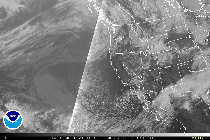
Hurricane High resolution Satellite images
 |

National Floodwarn Hurricane information and news centre
This page contains information on conditions for formation of hurricanes. We have Wind Sheer maps, Convergence & Divergence maps for help predicting where tropical storms and hurricanes will for or intensify. satellite images and discussions can be found on our main Hurricane Centre Page
Share /save is the easy way to add us to your favourite list and share with your friends
![]()
|
Floodwarn should not be used to replace the National hurricane Centre information at http://www.nhc.noaa.gov/ National Hurricane Center advisories and County / local emergency management statements supersede the informations referenced on this page. |
cyclones and hurricanes
| LATEST HIGH RESOLUTION HURRICANE SATELLITE IMAGES |
|
Current Atlantic Surface Weather Analysis

|
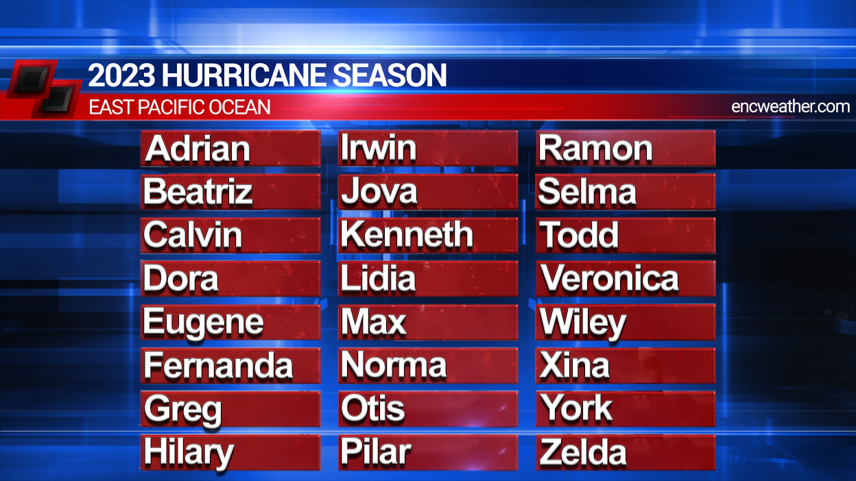
North East Pacific hurricane storm names
|
|||||
|---|---|---|---|---|---|
| 2011 | 2012 | 2013 | 2014 | 2015 | 2016 |
| Adrian | Aletta | Alvin | Amanda | Andres | Agatha |
| Beatriz | Bud | Barbara | Boris | Blanca | Blas |
| Calvin | Carlotta | Cosme | Cristina | Carlos | Celia |
| Dora | Daniel | Dalilla | Douglas | Dolores | Darby |
| Eugene | Emilia | Erick | Elida | Enrique | Estelle |
| Fernanda | Fabio | Flossie | Fausto | Felicia | Frank |
| Greg | Gilma | Gil | Genevieve | Guillermo | Georgette |
| Hilary | Hector | Henriette | Hernan | Hilda | Howard |
| Irwin | Ileana | Ivo | Iselle | Ignacio | Isis |
| Jova | John | Juliette | Julio | Jimena | Javier |
| Kenneth | Kristy | Kiko | Karina | Kevin | Kay |
| Lidia | Lane | Lorena | Lowell | Linda | Lester |
| Max | Miriam | Manuel | Marie | Marty | Madeline |
| Norma | Norman | Narda | Norbert | Nora | Newton |
| Otis | Olivia | Octave | Odile | Olaf | Orlene |
| Pilar | Paul | Priscilla | Polo | Patricia | Paine |
| Ramon | Rosa | Raymond | Rachel | Rick | Roslyn |
| Selma | Sergio | Sonia | Simon | Sandra | Seymour |
| Todd | Tara | Tico | Trudy | Terry | Tina |
| Veronica | Vicente | Velma | Vance | Vivian | Virgil |
| Wiley | Willa | Wallis | Winnie | Waldo | Winifried |
| Xina | Xavier | Xina | Xavier | Xina | Xavier |
| York | Yolanda | York | Yolanda | York | Yolanda |
| Zelda | Zeke | Zelda | Zeke | Zelda | Zeke |
Tropical Pacific Wide Visible Satellite Image

Western Atlantic Water Vapor Satellite Image
Tropical Atlantic Wide Water Vapour Satellite Image

Pacific & Western Atlantic Infrared Satellite Image

Tropical Atlantic Wide Infrared Satellite Image

Hurricane watch
Use this interactive map
+ or - to zoom out
Add latest satellite clouds or forecast tracks & positions


|
Indian ocean and Aarabian sea 
|


East Pacific

LATEST WIND SHEER AT UPPER LEVELS

LATEST WIND SHEER AT UPPER LEVELS

LATEST LOWER CONVERGENCE CHARTS FOR West Pacific


West Pacific
LATEST UPPER LEVEL DIVERGENCE CHARTS FOR West Pacific

LATEST LOWER LEVEL WIND SPEEDS FOR west Pacific


GFS prediction
GFS prediction wind sheer 48 hrs time
WIND SHEER AT MID LEVELS ( LATEST )

LATEST WIND SHEER TENDENCY CHARTS FOR WEST PACIFIC
To use this chart the current sheer speed is shown on right side and is shown as colour.
The tendency is shown as white for increase and blue dotted decrease in lines.
The number shows the amount of increase or decrease

EAST PACIFIC SHEAR TENDENCY

12 Hour Forecast - Favorable Environmental Conditions For Tropical Development
24 Hour Forecast - Favorable Environmental Conditions For Tropical Development
36 Hour Forecast - Favorable Environmental Conditions For Tropical Development
48 Hour Forecast - Favorable Environmental Conditions For Tropical Development
60 Hour Forecast - Favorable Environmental Conditions For Tropical Development
72 Hour Forecast - Favorable Environmental Conditions For Tropical Development
96 Hour Forecast - Favorable Environmental Conditions For Tropical Development
120 Hour Forecast - Favorable Environmental Conditions For Tropical Development
http://weather.unisys.com/gfs/init/gfs_pres_init.gif72 Hour Atlantic Wind Shear Forecast
Current Sea Surface Temperature Analysis
|


Infrared Satellite Images
North Atlantic:  |
Western Atlantic:  |
|
Caribbean:
|
Gulf of Mexico:  |
| : | |

Visible Satellite Images
|
Gulf of Mexico:
|
Western Atlantic:  |
Caribbean:  |
|

Water Vapour Satellite Images
|
Gulf of Mexico
|
Western Atlantic:  |
| : | |
Caribbean:  |
Northwest Atlantic: |

Infrared EUMETSAT image latest:

Courtesy of Eumetsat COPYRIGHT EUMETSAT 2010
Pacific Graphical Tropical Weather Next 24hrs Outlook
|


Eastern North Pacific Names 2012
Tropical Storm or Hurricane Agatha
Tropical Storm or Hurricane Blas
Tropical Storm or Hurricane Celia
Tropical Storm or Hurricane Darby
Tropical Storm or Hurricane Estelle
Tropical Storm or Hurricane Frank
Tropical Storm or Hurricane Georgette
Tropical Storm or Hurricane Howard
Tropical Storm or Hurricane Isis
Tropical Storm or Hurricane Javier
Tropical Storm or Hurricane Kay
Tropical Storm or Hurricane Lester
Tropical Storm or Hurricane Madeline
Tropical Storm or Hurricane Newton
Tropical Storm or Hurricane Orlene
Tropical Storm or Hurricane Paine
Tropical Storm or Hurricane Roslyn
Tropical Storm or Hurricane Seymour
Tropical Storm or Hurricane Tina
Tropical Storm or Hurricane Virgil
Tropical Storm or Hurricane Winifred
Tropical Storm or Hurricane Xavier
| Please support us by clicking the + button |
Hurricane facts

Download the Cardiff city music here
Forida web design | World Wide Weather | UK Discount Shopping | UK Adult Shopping
Firststop tyres Cheapest shopping|
A Tropical depression becomes a Tropical storm when sustained wind speeds reach 39mph. It remains a Tropical Storm from 39> mph till 73mph. A tropical storm becomes a Hurricane at 74 MPH (sustained winds)
Hurricanes have male and female names, but at one point only female names were used. Most hurricanes rage harmlessly in the sea. Australians call hurricanes, willy-willies. The New England Hurricane of 1938 is reported to have the fastest forward speed for a hurricane at 70 mph. The forward speed for an average hurricane is less than 20 mph. Hurricane season in the Atlantic Ocean runs from June 1 to November 30. The word hurricane comes from the Taino Native American word, hurucane, meaning evil spirit of the wind. A tropical storm is classified as a hurricane once winds goes up to 74 miles per hour or higher. Hurricanes are the only weather disasters that have been given their own names. Typical hurricane can dump 6 inches to a foot of rain across a region. The most violent winds and heaviest rains take place in the eye wall, the ring of clouds and thunderstorms closely surrounding the eye. Every second, a large hurricane releases the energy of 10 atomic bombs. Hurricane Floyd was barely a category I hurricane, but it still managed to mow down 19 million trees and caused over a billion dollars in damage. Most people who die in hurricanes are killed by the towering walls of sea water that comes inland. In the Pacific Ocean, Hurricanes are generally known as typhoons. In the Indian Ocean they are called tropical cyclones. The man who first gave names to hurricanes was an Australian weather forecaster named C. Wragge in the early 1900s. Hurricane season is from June to November when the seas are at their warmest and most humid, which are ripe conditions for a hurricane to develop. In 1938, a man on Long Island bought a barometer. The instrument signaled a hurricane but the man thought it was defective and went back to the store to complain. When he returned, he found his house has been swept away from a hurricane. It turned out the barometer was correct. |
|
| All american shopping deals |