Eruption disruption
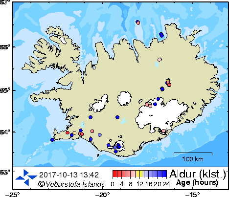
Iceland Volcano information and drifting ash cloud Monitoring the Katla Volcano
Floodwarn is provided completely free but the costs of running and hosting this site are not free. It is really appreciated that some users donate towards the running of the site and we have added a donate button to make this easier. If you can not donate please atleast click our + button it helps keep our site FREE for you
Live Webcams of Katla volcano and latest on the katla volcano |


The “Ring of Fire” also called the Circum-Pacific belt, is the zone of earthquakes surrounding the Pacific Ocean — about 90% of the world’s earthquakes occur there. The next most seismic region (5-6% of earthquakes) is the Alpide belt (extends from Mediterranean region, eastward through Turkey, Iran, and northern India. The greatest mountain range is the Mid-Ocean Ridge, extending 64,374 km (40,000 mi) from the Arctic Ocean to the Atlantic Ocean, around Africa, Asia, and Australia, and under the Pacific Ocean to the west coast of North America. It has a greatest height of 4207m (13,800 ft) above the base ocean depth. Subduction is the process of the oceanic lithosphere colliding with and descending beneath the continental lithosphere.
|